Red Sprites Look Like Alien Jellyfish Above Thunderstorms. They Were Only Filmed for the First Time in 1989.
Airline pilots reported strange red flashes above thunderstorms for decades, and scientists dismissed them. Then, in 1989, a University of Minnesota team testing a low-light video camera accidentally filmed one. Sprites turned out to be real electrical discharges in the mesosphere, part of a family of upper-atmospheric lights with names like elves, blue jets, gigantic jets, and ghosts.
For decades, airline pilots reported strange red flashes dancing above thunderstorms. The lights looked like nothing in the weather textbooks: jellyfish-shaped glows, columns, and curtains of red that bloomed high above the clouds and vanished in a fraction of a second. Meteorologists listened, and mostly discounted what they heard. Pilots were tired. The eye plays tricks at night. The reports went into the same drawer as UFO sightings.
The pilots were right. On the night of July 6, 1989, a team from the University of Minnesota pointed a low-light television camera at the sky as part of a rocket experiment and accidentally caught the phenomenon on tape: a pair of flashes shooting upward from cloud tops, later traced to a storm about 250 kilometers away. The images, published in Science in 1990, proved that something enormous and electrical was happening in the layer of atmosphere between the clouds and space, a region scientists had mostly ignored.
It took one more step for the phenomenon to get its name. During the 1994 Sprites94 research campaign, scientists led by University of Alaska researcher Davis Sentman called the flashes sprites, after the elusive air spirits of folklore. The name stuck, and it turned out to be the tip of a much stranger family. Sprites have siblings: elves, blue jets, gigantic jets, and ghosts. Together they are the transient luminous events, a hidden electrical zoo that plays out above our heads in nearly every large thunderstorm on Earth.
How a camera meant for rockets found them
The 1989 capture was almost pure luck. The Minnesota team, led by physicist John Winckler, was testing a low-light-level television camera for an upcoming rocket flight. The camera recorded 60 frames per second, far faster than the eye, and the researchers were watching the night sky from a site about 60 kilometers northeast of Minneapolis-St. Paul. When they reviewed the tape, two frames showed a pair of flashes leaping upward from distant cloud tops. The storm was roughly 250 kilometers away, far beyond the reach of the camera's intended target.
The discovery validated a prediction made more than sixty years earlier. In the 1920s, the Scottish physicist C. T. R. Wilson, who had won a Nobel Prize for inventing the cloud chamber, argued on theoretical grounds that electrical breakdown should occur high above large thunderstorms, not just inside them. Wilson even thought he may have witnessed such a flash himself in 1956. Nobody had the tools to test his idea, and the reports that did exist, from pilots, were treated as unreliable. The 1989 videotape was the first hard evidence that Wilson's high-altitude discharges were real.
The Science paper that followed, by R. C. Franz, R. J. Nemzek, and Winckler, described the flashes and their altitude. The phenomenon was later confirmed to reach between 50 and 90 kilometers above the ground, the mesosphere, where the atmosphere is thin enough that ordinary lightning cannot exist, but energetic enough to glow under the right electrical push.
Sprites are not lightning
The word sprite suggests something small and quick. The reality is the opposite. A sprite can span 50 kilometers across and hang in the sky for tens of milliseconds, a long time for an electrical event. High-speed cameras that film them at 100,000 frames per second show clusters of small ionized balls launching from around 80 kilometers up and streaking downward at up to a tenth of the speed of light, followed moments later by a second wave of balls moving upward.
Sprites are triggered by a specific kind of storm discharge: positive cloud-to-ground lightning, the rarer and more powerful strikes that transfer positive charge from the cloud top to the ground. A positive strike removes charge from the cloud so abruptly that it leaves a strong electric field above the storm, and that field breaks down the thin air of the mesosphere into glowing plasma. The result is a cold plasma discharge, more like the inside of a fluorescent tube than the hot channel of ordinary lightning. That is why sprites glow red-orange in their upper regions with bluish tendrils hanging below, and why they can appear as jellyfish, columns, or carrots.
Not every storm makes sprites, and scientists still do not fully understand why some do and others do not. NASA's Astronomy Picture of the Day notes that after more than three decades of imaging, the root cause of sprite lightning remains unknown apart from the general association with positive cloud-to-ground lightning. They have been recorded over North and South America, Europe, Africa, Australia, and Asia, and during Hurricane Matthew's passage through the Caribbean in 2016. Most large thunderstorm systems appear to produce them.
The family: jets, elves, and ghosts
Sprites were the first of these phenomena to be named, but they were not alone. As cameras improved, the family grew:
Blue jets shoot upward from the tops of thunderclouds and reach about 50 kilometers, roughly the top of the stratosphere. They were first recorded in October 1989, only months after the sprite discovery, on a space shuttle video taken over Australia. Blue starters are smaller versions that barely clear the cloud top.
Elves are the strangest members of the family: expanding rings of light that bloom at around 90 to 100 kilometers, in the ionosphere, when the electromagnetic pulse from a lightning strike slams into the thin air there. They are fast, usually lasting less than a millisecond, and they are not electrical discharges in the same sense as sprites. The name comes from the acronym ELVES, Emission of Light and Very Low Frequency perturbations due to Electromagnetic Pulse Sources, and they were named by Walter Lyons during the same era as the sprite campaign.
Gigantic jets are the rarest and the most spectacular. Where sprites form independently above a storm, gigantic jets are electrical bridges: a leader channel that starts as an intracloud flash between charge regions inside the thundercloud, then escapes upward and climbs all the way to the ionosphere, roughly 90 to 100 kilometers above the ground. They were first described in a 2002 Nature paper by Victor Pasko and colleagues, based on observations from Puerto Rico. Until recently they had been photographed only a handful of times, usually by chance.
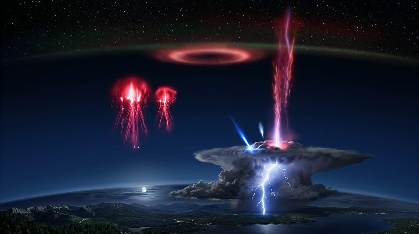
Then there are the ghosts. Sprites sometimes leave behind a faint greenish afterglow that lingers for hundreds of milliseconds at the top of the flash, long after the red light is gone. The glow earned the name ghost, and for years researchers assumed the green came from excited oxygen in the upper atmosphere, the same source as auroral green. A 2023 study in Nature Communications, led by María Passas-Varo and colleagues, captured the first spectrum of a ghost and found something different: strong emissions from iron and nickel, metals that rain into the mesosphere from meteors burning up high above the Earth. The green ghost afterglow appears to be partly the fingerprint of disintegrating space dust, excited by the sprite's energy.
Photographing them from orbit
Ground observers and storm chasers catch sprites from below, but the best view is from above. The International Space Station passes over storms at an altitude where the crew can look down through the clear air above the clouds and watch the flashes against the blackness of space. The station also hosts ASIM, the Atmosphere-Space Interactions Monitor, an ESA-built suite of cameras and sensors that detects transient luminous events from orbit and records their faint light signatures.
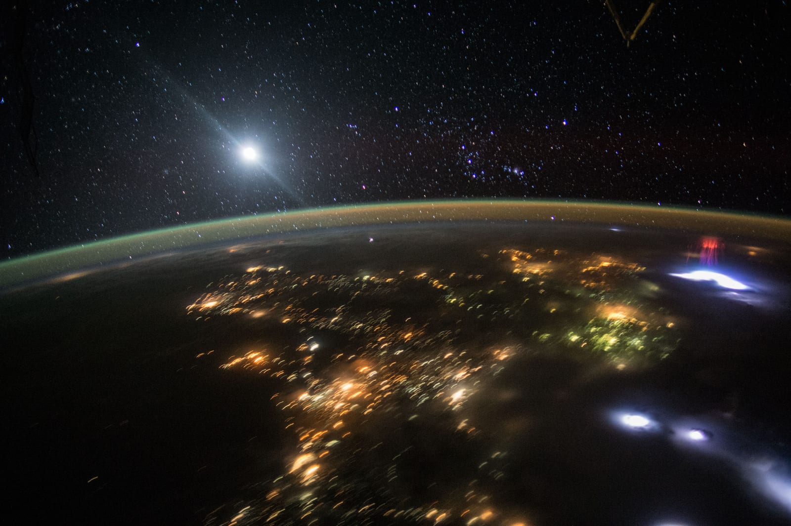
Two of the most striking images in the sprite catalog came from the station on a single night, August 10, 2015. Within three minutes, the Expedition 44 crew photographed two separate sprite clusters: one over the central United States, roughly 2,200 kilometers away, with the lights of Dallas in the foreground, and one over a storm near El Salvador, close enough that the jellyfish structure shows clearly. Those images, public domain, are among the most shared sprite photographs in existence.
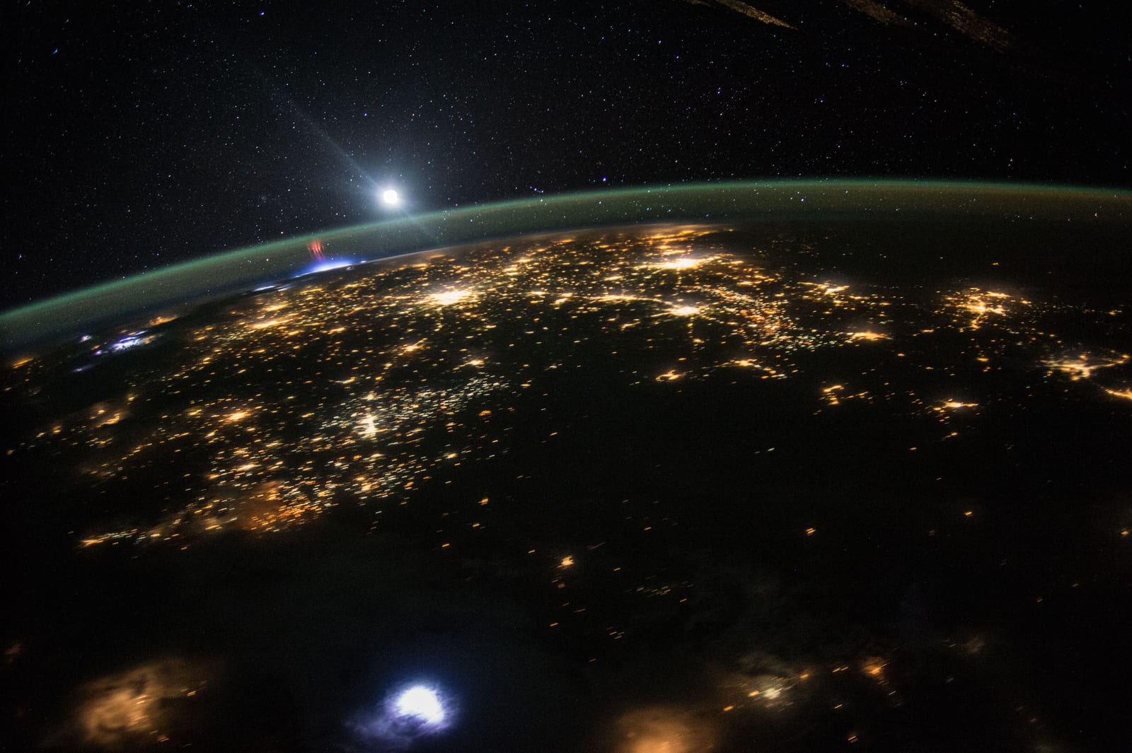
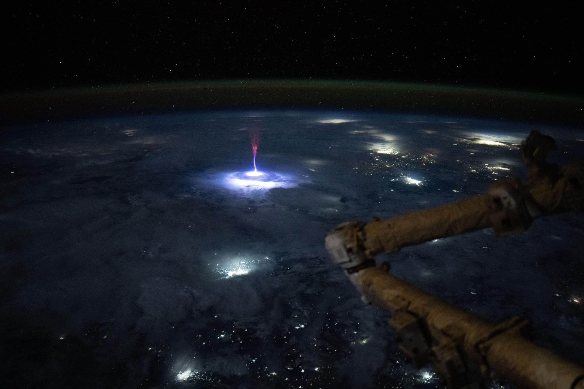
On July 3, 2025, NASA astronaut Nichole Ayers photographed an even rarer event from the station: a gigantic jet climbing from a storm near the U.S.-Mexico border. Ayers initially thought she had caught a sprite. Scientists from NASA's Spritacular project, a citizen science program that collects public observations of these phenomena, confirmed it was a gigantic jet, an electrical bridge from the cloud top, around 20 kilometers up, to the upper atmosphere near 100 kilometers. It was one of the clearest images of a gigantic jet ever taken from orbit, and it is the image at the top of this story.
The same physics plays out on other worlds. NASA's Juno spacecraft has photographed transient luminous events in the far-ultraviolet light of Jupiter's upper atmosphere, high above the planet's lightning-producing water clouds. Whatever drives these flashes on Earth is not unique to Earth.
Why the lights above the storms matter
The transient luminous events are more than a light show. They are part of the global atmospheric electric circuit, the slow, planet-wide flow of electric current between the ground and the ionosphere, and they transfer significant electrical charge between the storm and the upper atmosphere. Researchers are still working out what that means for the chemistry of the mesosphere, where sprites and their kin can alter trace gases, including ozone and greenhouse gases, faster than the quiet background chemistry would.
The flashes may also offer a warning signal. Because sprites are tied to positive cloud-to-ground lightning, and positive strikes are associated with the most intense and damaging parts of a storm, a sprite detection is a clue about what a storm is doing underneath. Scientists are studying whether sprite activity can help forecast severe weather, alongside the usual radar and satellite tools.
And the citizen scientists help. NASA's Spritacular project, running since 2022, invites anyone with a camera to submit sprite sightings, which researchers use to build the largest database of these events ever assembled. A phenomenon that was dismissed for decades is now documented by thousands of volunteers, many of whom photograph it from their own backyards.
The story of sprites follows the same arc as the Bloop, the mysterious deep-sea sound that turned out to be ice, not a monster: a mystery that pilots reported for years, that science dismissed, and that turned out to be real, physical, and stranger than the rumor. The lights above the storms were never ghosts or alien signals. They are the planet's own electrical weather, glowing in the thin air between Earth and space, and we have only been watching them properly since 1989.
Sources
- NASA Science: A Gigantic Jet Caught on Camera: A Spritacular Moment for NASA Astronaut Nicole Ayers - the July 3, 2025 ISS gigantic jet, sprite basics, and the Spritacular project
- NASA Earth Observatory: Red Sprites Above the U.S. and Central America - the August 10, 2015 ISS sprite photographs and their altitudes
- Passas-Varo et al., "Spectroscopy of a mesospheric ghost reveals iron emissions," Nature Communications 14:7810 (2023) - the first spectrum of a sprite ghost, showing metallic iron and nickel emissions
- Physics Today: Sprites, Elves, and Glow Discharge Tubes - the discovery and naming history, Wilson's prediction, and the 1994 campaign
- Wikipedia: Sprite (lightning) - mechanism, positive cloud-to-ground trigger, altitudes, shapes, and observation history
- Wikipedia: Upper-atmospheric lightning - the full transient luminous event family, blue jet and gigantic jet details, and ASIM
- Franz, Nemzek, and Winckler, "Television image of a large upward electrical discharge above a thunderstorm system," Science 249:48-51 (1990), DOI 10.1126/science.249.4964.48 - the primary first-detection paper (publisher link requires a browser)
- Pasko et al., "Electrical discharge from a thundercloud top to the lower ionosphere," Nature 416:152-154 (2002), DOI 10.1038/416152a - the paper that identified gigantic jets
- NASA Earthdata: The Role of Space Shuttle Videotapes in the Discovery of Sprites, Jets, and ELVES - discovery history (link requires a browser)
Hero image: NASA photograph iss073e0281502 by astronaut Nichole Ayers (public domain). Inline sprite photographs: NASA images ISS044-E-45553 and ISS044-E-45576 by the Expedition 44 crew (public domain). Altitude illustration: generated by the Impossible Universe Editorial Team based on the cited sources. NASA imagery is public domain; credit NASA.
Related on Impossible Universe
- The Mysterious Bloop Sound Was Heard Around the World. It Was Ice, Not a Monster. - another decades-old mystery that turned out to be a real, explained natural phenomenon
- Physics and Quantum Topic Hub - more on plasma, electrical breakdown, and the physics of the unusual
- Telescopes and Space Missions Topic Hub - the space-based observatories, from the ISS to Juno, watching Earth and other worlds
- Juno Just Caught Cosmic Rays Smashing Into Its Camera. The Glitches Are a Goldmine. - high-energy particles and radiation physics near Jupiter
- What Would Happen If the Sun Just Switched Off? A New Signal Could Tell Us. - space weather and the electrical environment around Earth