
A Civilization of Up to 3 Million People Carved Geometric Earthworks Across the Amazon. A New LiDAR Survey Shows How Many Are Still Hidden.
For decades, the southwestern Amazon was treated as pristine rainforest that had never supported large populations. A new LiDAR survey over 4,497 square kilometers of Acre and Amazonas states in Brazil found 432 geometric earthworks, 396 of them previously unknown, and the team behind it estimates the Aquiry civilization built 24,000 to 30,000 of these ditched enclosures across up to 183,000 square kilometers, with a peak population of 1.2 to 3 million around 200 CE. Here is what the survey shows, who the Aquiry were, and why the old story of an empty Amazon is falling apart.
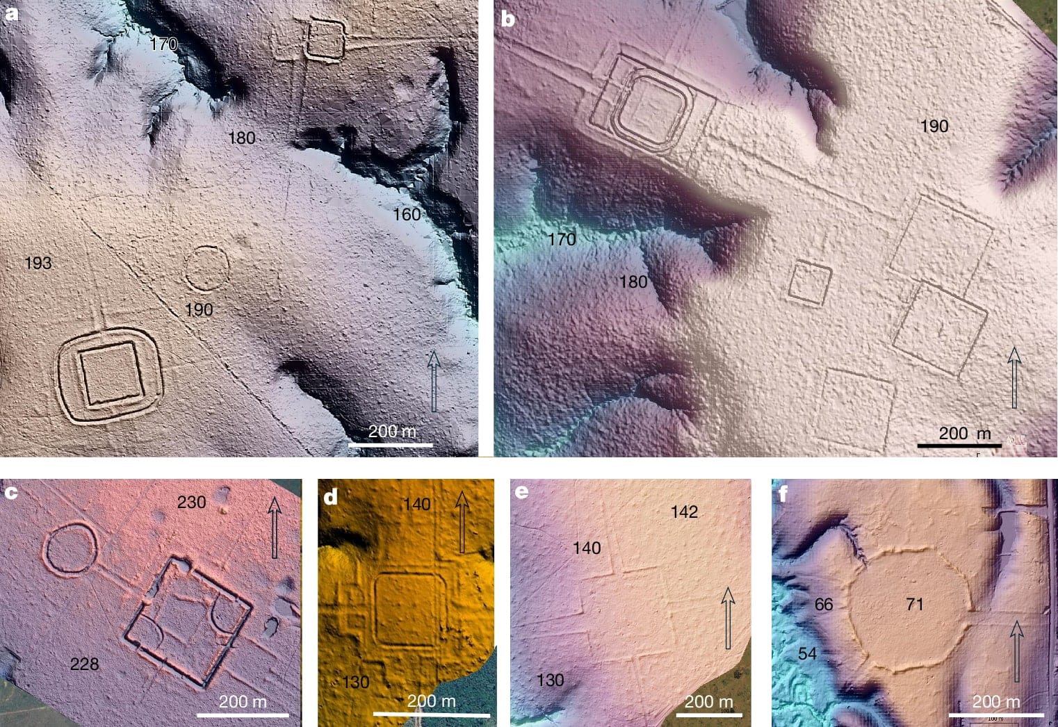
For most of the twentieth century, the Amazon was treated as a pristine wilderness: a forest so poor in soils and so hard to farm that it could never have supported large human populations. The evidence against that idea has been piling up for two decades. In July 2026, a survey published in Nature added what may be the largest single batch yet: LiDAR flights over less than 3 percent of Greater Amazonia found 432 geometric earthworks, 396 of them previously unknown, and the researchers now estimate the civilization that built them raised 24,000 to 30,000 of these structures across the southwestern Amazon.
The civilization has a name, the Aquiry, and it lasted more than a millennium. It was not a single kingdom or empire but a network of communities that shared traditions and built monumental ditched enclosures in circles, squares, octagons, and other geometric forms, connected by straight roads. At its peak, around 200 CE, the team estimates, the region it occupied may have held 1.2 to 3 million people. The Aquiry left no written records and no standing buildings; the earthworks and the forests shaped by their land management are almost all that survives.
What the survey found
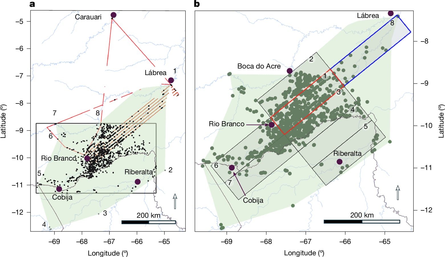
The study, led by Martti Pärssinen of the University of Helsinki, used airborne laser scanning, or LiDAR, flown in 2024 along ten transects totaling more than 4,400 kilometers over the Brazilian states of Acre and Amazonas. The scans covered 4,497 square kilometers, or about 1,736 square miles, an area representing less than 3 percent of Greater Amazonia.
Within that sliver of forest, the team documented 432 earthworks. Only 36 were known before. Added to roughly 1,300 structures found earlier through satellite imagery and aerial photographs, the new total for the region stands at about 1,700 recorded earthworks. The team then extrapolated from the transect sample, combined with the earlier surveys, and estimated that 24,000 to 30,000 earthworks may lie across an area of up to 183,000 square kilometers, the full extent the Aquiry appear to have occupied. The paper's title states the finding more conservatively: over 20,000 precolonial earthworks.
The extrapolation is an estimate, not a count. Only a fraction of the region has been scanned, and the number depends on how representative the transects are. But the direction of the error is what surprised the researchers: the earlier, pre-LiDAR figures were too low, not too high.
"What surprised us most was the extraordinarily large number of geoglyphs and other earthworks found within an area representing less than 3 percent of Greater Amazonia," Pärssinen said. "The scale of the archaeological record suggests that many other regions across Amazonia may have been far more densely populated and intensively modified than previously assumed."
Who the Aquiry were
The name Aquiry comes from the word Indigenous peoples used for the Acre River, which flows from Peru and Bolivia into Acre, passing through the heart of the civilization. The culture was introduced to the archaeological literature in 2021, after years of fieldwork in Acre, and it is the label researchers give to a multicultural complex of communities that shared a common sociocosmology, expressed most visibly in their monumental earthworks.
According to Bayesian modeling of radiocarbon dates, the geoglyphs were constructed between 600 BCE and 850 CE, with regional variations in form. The civilization peaked around 100 to 300 CE. The largest known geoglyph covers nearly 50 hectares, or about 123 acres; most range from 0.35 to 14 hectares. The ditches could be meters deep and 9 to 13 meters wide, with the excavated earth piled into embankments on the outside or on both sides of the ditch. The builders worked without metal tools and, the team believes, without draft animals.
The earthworks were ceremonial and political centers, not permanent homes. People lived in large wooden longhouses nearby, in settlements of a few hundred, and grew crops including maize, manioc, squash, and cotton, while managing the surrounding forest for fruit and nut trees. At certain times of the year, Pärssinen told ScienceAlert, the clearings around the great earthworks would come alive with ceremonies, gatherings, music, dancing, and athletic competitions. "At the center of many of these clearings would stand large geometric earthworks connected by broad and narrow roads," he said.
How LiDAR sees through the forest
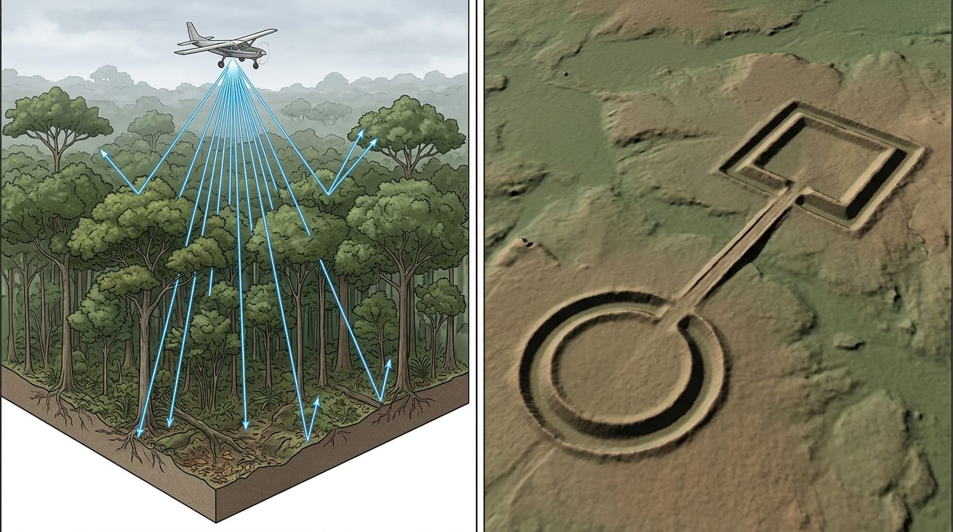
The technique behind the discovery is the same one that revealed the Maya city of Minanbé and dozens of other hidden settlements: LiDAR fires millions of laser pulses at the ground from an aircraft and measures how long each pulse takes to return. Most pulses stop at the canopy, but enough slip through gaps between leaves to reach the forest floor and bounce back. From those ground returns, computers build a bare-earth terrain model, effectively draining away the vegetation. Earthworks that are invisible from the ground and from ordinary aerial photos, because the forest has swallowed them, show up as crisp geometric relief.
LiDAR had been used in the Amazon before, most famously at Llanos de Mojos in Bolivia and in the Upano Valley of Ecuador, where it revealed sprawling urban landscapes. But those surveys covered relatively small, targeted areas. The Aquiry study is different in scale: long transects across a broad region, designed to measure how far the culture extended and to justify a population estimate for the whole area.
The end of the "empty Amazon" idea
The story of how archaeologists got here begins in 2002, when Pärssinen, Alceu Ranzi, and Sanna Saunaluoma flew over the Acre earthworks for the first time and saw monumental geometric structures and ancient roads connecting them across a region long regarded as pristine rainforest. "It completely transformed my understanding," Pärssinen told ScienceAlert. "More recently, I felt something similar when I came to understand that there may actually be up to ten times more of these earthworks in the region than I had previously imagined."
The new results put a number on that. One region of the southwestern Amazon now appears to hold as many earthworks as earlier estimates projected for the entire Amazon Basin, and roughly 20 times the number predicted for the whole southern rim of the forest. The population estimate for precolonial Greater Amazonia has climbed accordingly, from about 1.5 to 2 million in older scholarship to 5 to 10 million in current estimates.
"That old idea of a pristine Amazonia falls apart," Ranzi, a geographer at the Federal University of Acre, told Science.
The population estimate, and its limits
The peak population figure, 1.2 to 3 million people, is model-based. The team derived it from the number of earthworks and estimates of how many people it took to build and maintain them, applied across the extrapolated extent of the Aquiry area between roughly 100 and 300 CE. It is a wide range, and the researchers present it as a tentative estimate, the first of its kind for a large forested area of the Amazon.
The honest reading is that the exact numbers will shift as more of the region is scanned. What is unlikely to shift is the direction of the finding: a substantial, organized population lived in this part of the Amazon, modified the forest at a scale archaeologists did not expect, and left a landscape legacy that still shapes the region's ecology.
What happened to the Aquiry
The earthworks appear to have been abandoned between 850 and 950 CE, in a period of rapid decline. The timing matches the fall of other large societies in the Americas, including the Maya in Central America and the Tiwanaku and Wari cultures in the Andes, which raises the possibility of shared regional pressures, climate shifts, or both. So far there is no clear answer.
"Many questions remain unanswered," Pärssinen said. "One of the most important is what happened between approximately CE 850 and 1000. Why did this civilization disappear?"
The forest did what forests do: within about a millennium, it reclaimed the clearings, the roads, and the embankments. The ditches stayed, filled with soil and leaf litter, and today they are the only visible trace of a civilization that may have numbered in the millions.
Why it matters beyond archaeology
The finding is not only about the past. If the Aquiry and cultures like them shaped the Amazon's forests, soils, and biodiversity for more than a thousand years, then parts of the rainforest that look "natural" are partly cultural landscapes, with implications for conservation and for climate modeling that assumes a pristine baseline. The team made the point directly in the paper: if similar results are found elsewhere in Amazonia, the total precolonial population density and its effect on soil, forest structure, and biodiversity, and even some modeling of the global climate, should be reevaluated.
The 2024 survey covered less than 3 percent of Greater Amazonia, and it found 396 new earthworks in that sliver. The team's own estimate is that tens of thousands more remain hidden. Every future survey that points its lasers at the Amazon, the region that was once written off as too poor to support civilization, is likely to find more of what the Aquiry built.
Sources
- Pärssinen, M., Kalliola, R., Ranzi, A. et al. "Over 20,000 precolonial earthworks in the Southwest Amazonia." Nature (July 29, 2026), DOI 10.1038/s41586-026-10835-7 - the peer-reviewed paper: the 2024 LiDAR survey of 4,497 km², 432 earthworks (36 previously known), the Aquiry civilization, radiocarbon modeling of 600 BCE to 850 CE construction, and the population estimate. Open access, CC BY 4.0
- Nature news: "Earthworks spotted in the Amazon hint at huge ancient civilization" (July 29, 2026) - the journal's own news coverage of the discovery and its significance
- ScienceAlert: "'Completely Transformed My Understanding': Scientists Uncover Hundreds of Hidden Structures Beneath The Amazon" - survey details, the extrapolated 24,000-30,000 earthworks and 1.2-3 million population range, and Pärssinen's interviews on the 2002 overflights and the landscape at its peak
- Archaeology News Online: "LiDAR reveals hidden Amazon earthworks from lost civilization of up to 3 million people" - the Aquiry name and its "river of caimans" origin, the ceremonial-center interpretation, longhouse settlement, and the 850-950 CE decline matching other American collapses
- Popular Mechanics: "A Lost Civilization Carved Pentagrams Into the Amazon Jungle" - the regional total of roughly 1,700 earthworks, the 70,000-square-mile extrapolation, the ~123-acre largest site, and the no-metal-tools building estimate
- Archaeology Magazine: "Hundreds of Geoglyphs Discovered in Amazon Rainforest" (July 31, 2026) - the survey coverage and the population-estimate method based on earthwork counts and maintenance labor
Hero image and area map: figures 2 and 3 from Pärssinen et al., "Over 20,000 precolonial earthworks in the Southwest Amazonia," Nature (2026), DOI 10.1038/s41586-026-10835-7, used under the Creative Commons Attribution 4.0 International license of the open-access paper. LiDAR technique diagram: generated illustration by the Impossible Universe Editorial Team.
Related on Impossible Universe
- A Lost Maya City Was Found Hidden in the Mexican Jungle. It Survived 1,000 Years Undisturbed. - the other great LiDAR reveal of 2026: a buried city found the same way, with the lasers confirmed on the ground
- Scientists Pulled Ancient Human DNA From Cave Walls for the First Time - another frontier technique changing how archaeologists study the deep past
- History and Archaeology Topic Hub - more stories on reading the buried past with DNA, fossils, and remote sensing