
A Lost Maya City Was Found Hidden in the Mexican Jungle. It Survived 1,000 Years Undisturbed.
In June 2026, archaeologists announced the discovery of Minanbé, a Maya city hidden for more than 1,000 years in the Calakmul Biosphere Reserve of Campeche, Mexico. LiDAR scans revealed a monumental core of roughly 15 hectares with plazas, palaces, terraces, and a water management system. On the ground, the team found a pyramid temple more than 13 meters tall in the Río Bec style, 14 carved stelae and altars, and a monument recording the date 5 Ajaw, or AD 849. There were no signs of looting anywhere on the site.
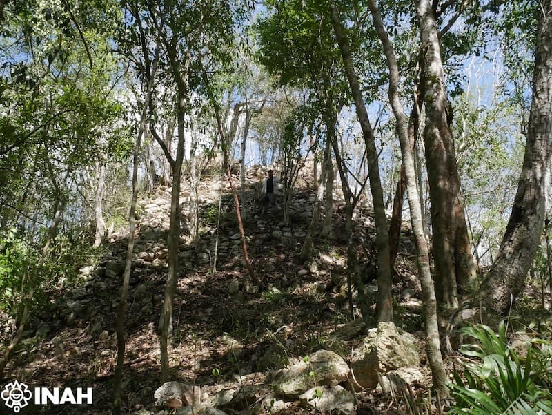
On June 22, 2026, Mexico's National Institute of Anthropology and History (INAH) announced a find that its own archaeologists called exceptional: a Maya city hidden for more than 1,000 years in the Calakmul Biosphere Reserve of Campeche, with no signs of looting anywhere on the site.
The city is named Minanbé, a Yucatec Maya phrase that means "there is no road." The name fits. Reaching it meant cutting a five-kilometer path through dense jungle with machetes, then continuing by all-terrain vehicle and on foot. No old logging roads led there, which was the first good sign. Ivan Šprajc, the Slovenian archaeologist who has led the region's exploration for three decades, called it the first intact site his team had found in three years.
"Compared to other places where we did surface surveys, access here was much more difficult," Šprajc said in the INAH announcement. "In the last three years, this is the first one we've found intact, with no signs of looting."
A city revealed by lasers
The team did not stumble onto Minanbé. They saw it first through LiDAR, a laser scanning technique that fires millions of pulses at the ground from an aircraft and measures how long each one takes to bounce back. Most pulses stop at the forest canopy, but enough slip through the gaps to map the bare earth beneath, revealing structures that are invisible from the ground and from ordinary aerial photographs.
LiDAR data for the zone north of Calakmul had been collected years earlier, but the settlement only became clear when the specialists examined the terrain models. What the scans showed was a monumental core of roughly 15 hectares: plazas surrounded by palatial and religious buildings, terraces, and an extensive water management system with wetlands and hydraulic channels.
"LiDAR is a powerful scanning method," Šprajc said. "It allows us to see through vegetation, identifying features that stand out from the natural terrain."
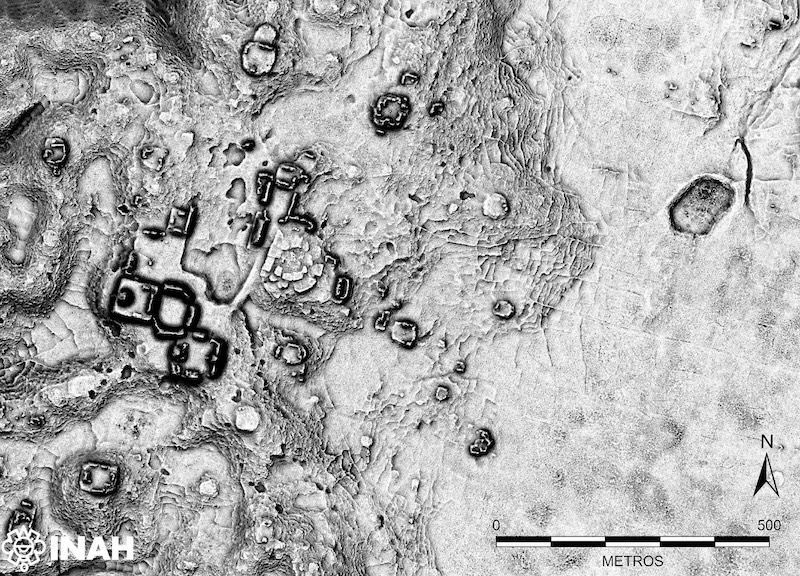
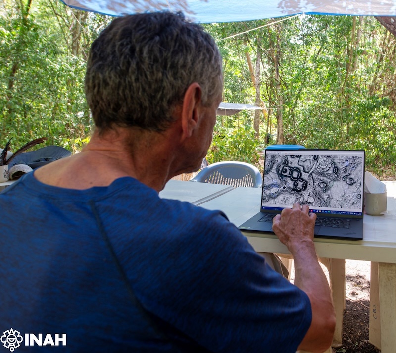
The dry-season field campaign, carried out from March to June 2026 by a Mexican-Slovenian team including archaeologists Atasta Flores Esquivel, Israel Chato López, Quintín Hernández Gómez, and Vitan Vujanović, verified the scans on the ground. What they found matched the lasers: an urban core with plazas, ceremonial and residential buildings, terraces, and a network of channels and wetlands that managed water across the settlement.
A 13-meter temple and 14 carved monuments
The tallest structure at Minanbé is a pyramid temple that exceeds 13 meters, built in the Río Bec style, a regional architecture known for tower-like temple facades, finely cut stone, and decorative moldings. Vujanović, who documented the structures, said it was the first reasonably well-preserved temple he had been able to record.
The team registered 14 stelae and altars, several of them carved with hieroglyphs, arranged at the end of a causeway that connects the central and northeast sectors of the city. One monument is older than the rest: an altar carved in the late seventh century showing a ruler wearing a feathered headdress, a decorated chest, bracelets, and necklaces.
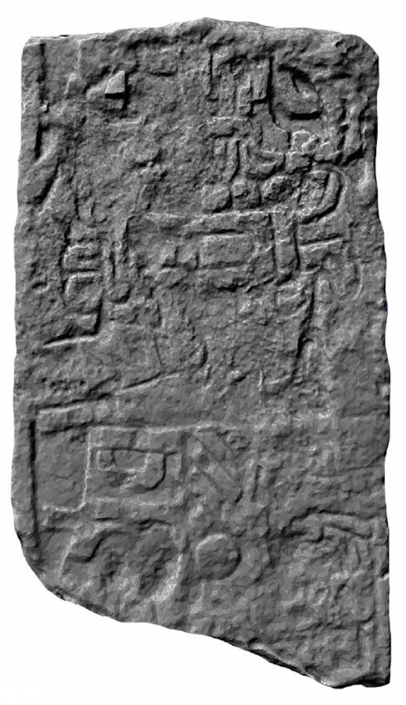
The most significant monument is Stela 1. At its top, a figure wields a knife or axe to decapitate another individual. Nearby, a calendrical sign records the date 5 Ajaw, which corresponds to AD 849, in the Terminal Classic period.
"This is an important key," said Octavio Esparza Olguín, the project's epigraphist, "because we can think that the whole set of monuments, or some of them, were erected for that moment of the Terminal Classic, close to the abandonment of the sites of the region, which happened in the 10th century AD."
That timing matters. Minanbé was not a city that died early. It was still erecting monuments in the ninth century, in the period when many southern Maya cities were already in decline, and it appears to have persisted until the region was largely abandoned around the 10th century. The site also shows that some monuments were intentionally altered in antiquity, a practice documented at other Terminal Classic Maya centers.
What the site means
Minanbé sits in the Central Maya Lowlands, a region that may have held 9 to 11 million people at the height of the Late Classic period, between AD 600 and 900. It joins a growing list of cities found by Šprajc's teams, including Chactún in 2013 and Ocomtún in 2023, evidence that large parts of this jungle still hold undiscovered settlements.
The discovery also raises new questions about the last centuries of Maya occupation. Archaeologists are investigating whether groups from the north of the Yucatán Peninsula may have moved into the region during the Terminal Classic, and whether that movement contributed to the shift in political power after the decline of local cities.
"Each new site helps us better understand the complexity of Maya civilisation," Šprajc said. "At the same time, it opens new questions that will require further research to answer."
Minanbé is not open to visitors, and its exact location is being kept restricted to protect it. For now, the city that means "there is no road" is one of the best-preserved windows onto the end of the Maya Classic era, still waiting for the questions that will be asked of it next.
Sources
- INAH Bulletin: "Bautizan como Minanbé, 'no hay camino', a ciudad maya virgen al norte de la Biosfera de Calakmul" (June 2026) - the primary announcement from Mexico's National Institute of Anthropology and History, with details on the 15-hectare core, the 13-meter Río Bec temple, the 14 monuments, and the 5 Ajaw (AD 849) date
- Heritage Daily (June 2026) - coverage of the discovery with additional context on the site west of Chactún and the water management system
- The Art Newspaper (July 1, 2026) - interview-based coverage including Šprajc's LiDAR explanation and the epigraphist's reading of the decapitation scene and 5 Ajaw date
- Smithsonian Magazine (July 2026) - coverage including the late-seventh-century altar with the feathered-headdress ruler
- ARTnews (July 2026) - coverage of the 43-foot pyramid temple, the 14 carved monuments, and the machete-cleared access route
Related on Impossible Universe
- Scientists Pulled Ancient Human DNA From Cave Walls for the First Time - another frontier technique changing how archaeologists study the deep past
- These 540-Million-Year-Old Fossils Were Thought to Be Animals. Then Scientists Looked Closer. - how modern analytical tools rewrite what we thought we knew about ancient life
- Real Maps for Places That Never Existed - how institutions treat maps of fictional worlds as real cartographic objects
- Millions of Smithsonian Objects Are Waiting for Better Stories - open-access museum collections as a story mine for history and science
Hero image: Pyramid temple at Minanbé, photo by Vitan Vujanović / INAH, from the official INAH bulletin (June 2026). Inline images: LiDAR visualization and three-dimensional monument scan, credit INAH. All images published in the INAH press bulletin for editorial use with credit.